Showing posts sorted by date for query autopilot. Sort by relevance Show all posts

Sunday, January 11, 2026

2026 Haul Out

Eximius is on the Hard


It's time. Eximius needs a butt wipe and a check that all's well below the waterline.

Our plan was to Haul out at Playboy Marina in Dania, South Florida today, Jan 6th 2026 at 09:30am. Our buddy boat, Spruce Goose was scheduled to haul out immediately after us. We're both Members of the Hillsboro Inlet Sailing club and have helped each other several times in the past few years.

To get to Playboy for 09:30am, we needed to leave our dock at 06:30-06:40am so that we can make each of the bridge openings as we motored South to the Dania Cut. Mike (Spruce Goose) has two more bridges than us so he planed to leave his dock at 06:00 in order to make the 06:15 14th St Bridge opening. 

It seems we both left our docks on schedule as we met up waiting for Commercial bridge to open at 07:00am, so the planning of the past few days worked out just fine.

We both motored through Commercial bridge, current was starting to flood against us but easily managed.

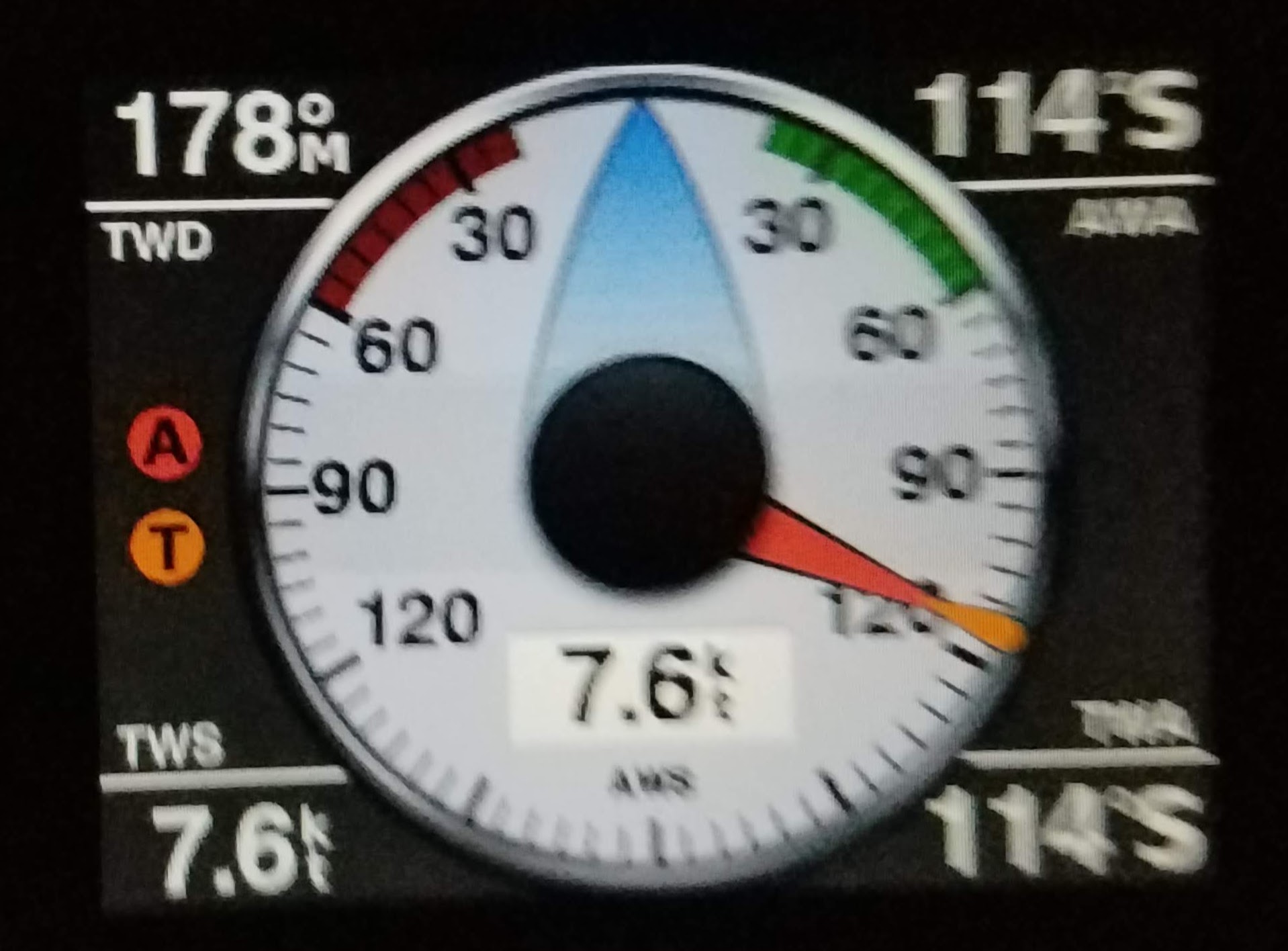
Shortly after passing the bridge, Peggy noted steam coming out of the exhaust and the engine temperature climbing over our usual less than 150º F and the exhaust was dry, not spitting the cooling raw water from the heat exchanger. This normally means we have picked up something into the Raw Water inlet or that the Raw Water Filter was blocked.   We moved to the middle of the channel and shut down the engine so that I could check both of those possible issues.

With the engine off, I went down to the cabin and into the head. The water filter is in the cabinet under the head sink. I shut the Raw water thru hull and unscrewed the Raw water filter from it's housing. It had some debris, but not enough to stop flow.
Next I eased off the two hose clamps that secure the water filter hose to the Thru hull. I keep an 18" pipe snake nearby that cabinet, with the hose removed, I pushed the snake down into the tube of the Thru hull and then opened it. Some water came in, not a lot. I used the snake to clear any obstruction - AT LEAST - that's what I thought I had done.
After putting everything back together, Peggy re-started the engine. Still no wet exhaust! Grrr. It could be the Raw Water Pump Impellor. 
AT this point I felt that the fix would take more time than I had just floating around in the ICW.  So I went forwards and quickly dropped 40'  of anchor and chain. 
Then I quickly put my tools together to change out the impellor and pulled a new impellor out of my engine spares box. 
Four screws and the Oberdorffer pump cover plate was off. The Impeller looked great! With the cover off, Peggy did a quick engine Start - n - Stop and I could see the impellor turning without issue. Again, I put everything back together and asked Peggy to restart the engine -  again, Dry exhaust. Peggy asked if I would double check the Thru Hull. It only takes a few minutes, so I went through the process again spending a little more time trying to clear anything in the tube using the snake.

Ok, let's try again before calling for a Tow from Boat US ( we have the towing package ) . 
Peggy restarted the engine which had dropped to around 150º F and we watched as the exhaust spat out a healthy amount of water. Cool ( sorry couldn't resist that Pun ). I hauled in the anchor and Peggy got us underway once more.

During all of this, Spruce goose kept going for the next timed bridge opening of Oakland Park Blvd Bridge and we agreed that he should take the first haul out time of 09:30am and I'll do my best to catch up. Had we needed a tow by Tow Boat US, they would not have had to stop waiting for the bridges, so we should have been able to get their on time.

We made all of the bridges but had lost a half hour. Mike pulled out at 09:30 and called us to let us know he was on the hard and blocked up. So we pushed the throttle and got to the Playboy haul out at 10:15 and the team and boat hoist were waiting for us.

Peggy has always had difficulty climbing over the front of the boat to get ashore, but the haul out team eased Eximius over to the Port side and Peggy was able to easily climb the gap.

With Peggy ashore, the Playboy crew moved the boat onto the hard and started pressure washing the boat below the waterline.

First thoughts - looking good!
The Ablative paint has ablated especially at the waterline, but no blisters, hardly any barnacles - that would be expected as the company ( Poseidon Marine Services ) only cleaned the hull less than two weeks ago - like every month.

I headed into the office to get the paperwork signed with Lisa the Office manager, we remembered each other from our past visits to Playboy - most of the crew seemed familiar.

Once the pressure washing was complete, they moved the boat to it's temporary home, blocked and lowered the boat on stands, each chained together, then the boat lift crew moved off with the lift.

Patagonia Marine Services ( Members of HISC ) got to work pretty much immediately.  They quickly setup an access ladder on the Stbd side of the boat. Leandro stopped by and confirmed the work to be done. Peggy & I decided it was lunch time, after all, we had been on the go since 04:00 today.

Mike had arranged for his good friend, Joyce, would pick us all up at the boat yard and take us back to our boat docks where our trucks were waiting to take us home - it was already a long day.

Wednesday Morning, we stopped at Lowes to pickup some Zep Polish remover as we planned to apply Zep again before we splash after getting the bottom job complete. The we drove down to Playboy, it took about 40 minutes all told.

Down at the boat, we could see that Patagonia had completed the sanding of the hull below the water line and had already applied the first coat of paint - it was looking good.

Time to get started on the work that we planned to do.
#1: Investigate the Rudder Post packing gland. There's a chance that it's leaking - at least there was some water in the mini-bilge between the rudder post and the PSS shaft seal.
It was dry! no indication of any leakage from the rudder tube. Move that one off the list but make a note to look for another culprit for the water leak.

#2: Check the drain and exhaust hoses and connections. They are all about 38 years old. They all looked good except one. The Exhaust hose it attached with two hose clamps to the Thru Hull. One had broken, corroded, so it and it's buddy both need to be changed out. I have spares onboard. Should be an easy task but it's not. I'm not sure of the various levels of Boat Yogas but I'm pretty sure you have to be some kind of Master Yogi to be able to reach those clamps while almost upside down, barely any space to put your leges and at least 5 points of contact are required in order to be able to turn a nut driver in order to remove and replace those hose clamps.

#3; Adjust the Auto pilot Rudder Sending unit that is attached to the Rudder Quadrant underside. Another " Hey dude, see if you can get a wrench onto that link " worse, I installed it originally - check my blog articles. But I was a couple of years younger and had a little more bend in my back.

Lunch time:

#4: Install a cockpit light in the hole that was currently occupied by the, no longer functional, Auto Pilot Control unit on the Stbd side of the Cockpit - Easy job except the hole for the old unit is about 3" around - too big.  I'll make a cover for the hole and install the new lamp in that cover.

#5: Clean out the Thru hulls for the head Sink, shower sump pump and the Engine Raw Water inlet.
Done - Woo Hoo! Cross that one off the list

We're done for the day.

Next day was time to polish the hull, the contractors had completed the sanding and application of the 1st coat of bottom paint.

We use the polish stripper to wash off the previous polish that we applied 2 years ago. Then, after several rinses, we started on the application of the hull polish. By the time we had completed 4 coats, we were both pooped! My Son turned up to give a hand, but we had done the heavy work. He was able to spend time assisting with the install of our new cockpit light. We got the wiring run from the Stbd aft side of the cockpit, around inside the transom and then forwards on the port side into the port side locker.

Saturday, we went straight to work applying a couple of coats to the port side and another to the starboard. While that was drying, I worked on completing the wire run from the aft locker, through the head shelving unit, into the cabin and down into the area of the electrical control panel.

That panel continues to cause nightmares, it's such a mess, I really will get around to reworking the entire control panel and all of the wiring. Soooon!

A few more coats of hull polish and we're heading home, there's a HISC Landlubbers party this afternoon and don't want to miss that.

Sunday. More polishing, but enough. I reinserted the depth transducer, re-connected the Raw Water strainer ( that's another project ) and cleaned up the exhaust muffler hoping that we can identify where the exhaust leak is occurring.


Took twenty minutes out to replace the Heat Exchanger Zinc.

Definitely needed the change out. I'm guessing that our new dock located in more salty water is the cause.

I did peel off the label from the new zinc.

New zincs are on my list from the marine store.

That's it for today at the yard.


Back at home, I drilled out the new Cockpit Lighting Panel to house a switch.

Looks pretty good. The panel completely covers the old hole from the Original Raymarine Autopilot control unit.

I should be able to install it tomorrow - Monday.


And, the result of this:


Ok, folks, that's the 2026 Haul out wrapped up. We splash on Tuesday at 09:30, stopping by the 15th St Pumpout facility once we pass the 17th St Causeway bridge, then it's back to our dock. We'll finish off a couple of jobs at the dock on Wednesday, then, who knows? Perhaps we'll get out on the water for a couple of nights.

See you out there.


Thursday, September 4, 2025

Review of Aqua Maps

Review of Aqua Maps Navigation App.

I have been using Aqua Maps for several years. Initially I tried it out when it first came to market, at that time I was not impressed, but a couple of years later I revisited it and was impressed. Very recently, they have updated the software with a new feature - Route Planner - which does what it says, use it to plan your route.

But first let me drool for a while about one feature that I use every overnight trip. The Anchor alarm.

Some background: I have probably tried at least 15 different anchor alarm apps and none of them have made the grade and compared to Aqua Maps they were complete failures, so I'm not coming from a blank starting point. Oh, and I'm not being sponsored in anyway by Aqua Maps.

Ok, about the Aqua Maps Anchor Alarm. Here's a typical use for me.

On my Samsung Tablet which has a built in Sim Card so it's always able to connect to the Internet, I'll open Aqua Maps and set the Anchor Alarm. The program allows for setting the alarm during the actual drop of the anchor, ie. The anchor is where you are! which of course is not where you will be when the rode is let out. 
Sailing in South Florida, most of the anchorages are pretty shallow - 8' to 16', taking tides into account, down here they are mostly less than 3' so our depth at the anchor will be around 8' to 19' with the tide changes. We typically put out a 5-1 scope but if the weather is likely to deteriorate, I'll go for at least a 7:1 scope. So it's quite normal to let out 80' of chain at anchor. I'll set the anchor distance to 100', just to give a bit of wiggle room.

Of course, there is also the option to set the alarm after anchoring. ie. The anchor position is not where you are! The app has an excellent method of setting the alarm by using GPS, angle to point to the anchor and the distance from the anchor. Both methods work really well.

Now the alarm is set, and if it goes off, then you'll know it, most likely if you are anchored nearby us then you'll know it too! It's like all hell breaking loose! It cannot be ignored. Let's be real, that is exactly what you want even if you're wrapped up in a comfy berth at 2-o-clock in the morning! It's a one touch button to cancel the alarm so that the issue can be dealt with.

This is all really good, several other apps do something similar but Aqua Maps certainly has real sailors working for them and it shows. 

But Wait There's More.  If I'm not on the boat then I won't hear the alarm - Alarm Mirroring to the rescue. I have Aqua Maps installed on my Samsung phone too! If I turn mirroring on in the app on the tablet and confirm I want to use the mirroring system on my phone, then Aqua Maps mirrors the Boat's view and alerts just as the tablet does on board. So if I'm within range of a cell tower, both on the boat and ashore, then I'll get the alarm reports ashore.

I use this feature whenever we go ashore in the dinghy and being able to mirror the alarm system is a huge stress relief.

In short, Aqua Maps is worth the money even if it's just for the Anchor Alarm system.

Ok. What about their new feature - Route Planning.

Prior to this new update, route planning was easy, just click on the chart where you want the next waypoint be and save it.  Pretty easy, it would take a while, perhaps a few minutes, if you wanted to plan a route that has a lot of turns, but generally very quick.

Route Planning - Click the Start, Click the destination, Save, Done! Review and tweak if you need/want to. 

Cards on the Table: We have a full Garmin system on our boat and a NavLink2 wifi server to connect our boat data with Aqua Maps running on our phones or tablet.  The beauty of this setup is that I can run Garmin Helm on my tablet to mirror the chart plotter or I can view the NEMA 2000 data ( Wind, Water Speed, Heading, etc. ) inside of Aqua Maps.

How do we use Aqua Maps on the boat?
When we are planning a trip while in the cabin or cockpit, Aqua Maps is on screen, we have a RAM mount at the helm which can hold either the Tablet or a Phone, so we can have Aqua Maps at the helm, we use it as a backup - we've had a Chart Plotter failure before and it's stressful here in South Florida where there a lot of high speed boats around, plus, our Draft is 5'7" ( plus our tools ) and it's skinny water around here in many of the inlets. That backup is important.

What features do we like the best. The amount of info about the local areas are a huge value and Aqua Maps digs in. Yes it has Satellite view ( like Google Maps ) and a lot of local user info too. 

If i did not have a Chartplotter, then Aqua Maps could fill those shoes, it does not link to our Autopilot that's not a surprise, but if I didn't have a Chartplotter then I would probably not have an Autopilot.

Oh, I forgot to mention the GEC account. We have the full Aqua Map system and that include access to maps around the USA and a GEC account. That's basically a file storage for map data - gpx or kmz files. This gives me the option to upload Route files from my phone or tablet to my GEC account, I can then review them on my computer.

Finally - What about Customer Service?
The proof is in the puddin.
I had an issue when they first released the Route Planning feature, I sent one email to their tech support and had a response the next day and a fix the next day. Nuff Said.

Ok, if you have not got the app yet, take a look at their website. https://www.aquamap.app/
The App is available for both Android and IOS.
All of the good stuff requires a subscription, it will not break the bank.

Paul Alcock
Skipper of the Sailing Vessel Eximius - 1987 Catalina 34 - Tall Rig Fin Keel mostly found in South Florida.

See you on the water. 


Saturday, May 24, 2025

Fort Lauderdale to Jensen Beach

 Cruising with the HISC from Fort Lauderdale to Jensen Beach Florida

Ok, we're loaded up. Boat is prepped, Water tanks full, Fuel Full - Two more 5 gallons tanks ready to put onboard, 10 gallons of gasoline for the outboard and Generator, Fridges - both Full, Wine, Rum, Whisky, Meals for 5 days and more. Bedding, Towels, and more, all on the boat and stowed. New item- The Ice Maker is on board, but not plugged in, it makes Ice in 7 minutes so just plug it in when needed. We even stored our Tower of Bricks game for the Rendezvous on Saturday. The Navigation electronics are in place and tested. 

We both have our 'Bags' packed, toiletries too, Meds ready to pack first thing in the morning. Did we forget anything??? Of course but we won't find out until we need it.

Plan to leave the house at 05:45 to arrive at the dock at 06:15, close enough. We arrived at the dock at about 06:35.
That's a good start.
Unusually quickly,  we put the fuel cans on the stbd deck,opened all the through hulls and got the engine running.  I prepped the dock lines while Peggy prepped for leaving the dock. We were off the dock before 6:55. WooHoo

We had a minor issue en-route to Atlantic Bridge. Pegs thought we had picked up a bag on the prop but we were OK. Running the prop in reverse at highest rpmdid the trick. We did have some smoke coming out of the exhaust. But I put that down to unburnt fuel. It cleared by the time we arrived at the bridge.  Then easily on to 14th street bridge and around the corner to the HI Inlet.  Summer Wind arrived at the same time. Once out of the inlet we turned NE,  heading 3nm offshore for a pump out. That's when the 2nd issue appeared. We planned to do a pump out before arriving at Lake Worth. However,  gremlins snuck into the black water tank and into the Macerator pump.
I keep a spare onboard but did not relish replacing it with the tank half full. As I thought about it,  I noticed there was a slot on the end of the pump driveshaft. A few turns and try the pump again..... Another score for the day. 

It was an awkward sail, wind around 15° which caused us to take some long tacks and that before the forecasted pm storms.  Chris was about a mile ahead of us, gotta love AIS. We both agreed via #68 that it was best to motor the rest of the way to Lake Worth. I set an Auto Guidance route on our chart plotter and set the Autopilot on the bearing of the first leg. The Garmin will control the Raymarine AP, but not if the track is from auto Guidance.
It was a long, but uncomplicated run up to Lake Worth. 

I did splurge for this trip. Introducing my new Tilley Airflow Broard rim hat. It already has a story.
As we approached the lake Worth Inlet,  Peggy turned us into wind while I lowered the mainsail. Of course, my new Tilly hat decided to go for a swim. $87! Hat overboard !!! Peggy turned the boat hard to stbd while keeping the hat in sight. Great time to practice our MOB action. Pegs turned past the hat and headed back up to wind with the victim just off the stbd bow. The hat was easily reached with the boat hook and retrieved ,wet but no worse for wear.One of the features of the Tilleyhats is that they float. Cross that test off the list.


Chris, on Summer Wind, reached the mooring field a few minutes before us so we stayed out of his way as he picked up their mooring,then Peggy turned us towards our designated mooring and we caught it first time despite the fast flowing current.  We'll done Pegs ,good job at the helm.
A quick chat with Chris about the trip and the plan for the morning, then it was time for a break to cool down,  I heard a whiskey and ginger calling me and a glass of wine for Pegs. 

We ran the AC on battery for a couple of hours and we both had a hot shower,  the benefit of running the engine earlier.

Dinner was a meal Peggy had prepared at home, Shrimp Fetucini followed with Mango bread and some dark chocolate. 
As Luke on the sailing brothers YouTube channel says.... DELICIOUS. 

Chris and I texted about the lack of 'weather' tomorrow, Friday. Looks like we'll motor most of the way up to Port St Lucie. 

Time to clean up the galley and secure the boat for the expected rains this evening. 

Thursday, October 24, 2024

Chart Plotter failed

Chart Plotter failed - time to upgrade

Before the Failure :( 


Our 12 year old Garmin 741XS Chartplotter failed, at the dock, it would not turn on after we shut it down. This has happened three times now, once on the ICW, once when heading in from the Ocean and now at the dock while testing it.

Circuit Breaker - On √ 
Fuse √
Power at the connector to the Chartplotter √

It just will not boot up! Grrrrr.

Time to upgrade.

This is our 3rd Garmin Chartplotter, two on a previous sailboat and this one which came with the boat when we purchased it in 2015. 

We have a full NEMA 2000 system plus a Garmin HR 18 Radar. Our helm station is nicely setup with the Chartplotter, GMI instrument to show wind and pretty much any other data from the system, and our Raymarine Evo 100 Autopilot.  So ideally, the new Chartplotter will fit in the same footprint as the old one.

Down to West Marine with the old Chartplotter in hand we browse the available units.

Garmin GPSMap 943xsv
Multifunction Display with US and Canada Navionics+ Charts


Closest in size is the Garmin GPSMap 943 xsv. We spend a while discussing it with the WM rep and were able to confirm with Garmin Tech Support that our older Garmin HR 18 Radar would work with the new unit and that it would physically fit on our helm station. The power connection was also the same and the only other connection we were concerned about was the NEMA 2000 and that is standard.

Thirty minutes later we were walking out of the store with our new Chartplotter. WM confirmed that if it did not work on our boat we could take it back.

That night we both plowed through the install manual and the user manual. We also watched several YouTube videos on how to connect the GPSMap 943xsv to Active Captain and how to get the latest charts.

The new Chartplotter came with a 1 Year Navionics + subscription which means we can get the high res charts and the Auto Guidance feature - very cool!

After registering our new Chartplotter using Garmin Express on my laptop, we were able to log into Active Captain on my Tablet and download chunks of the Navionics + Charts for our area.

So far so good. Now time to install the new Chartplotter on the boat.

Step 1 - Physical mount it to the helm station. Our old Chartplotter mount is almost identical to the new, maybe a couple of millimeters narrower.  So 4 bolts removed, new mounting bolted down, ready to install.   --- 1st issue!

The mount has slots which hold the Chartplotter in place with a couple of large turn screws, but the diameter of the threaded part of those two turn screws are just a tiny bit too large, it's really difficult to get the screws into those slots.  Once I figured that out, it was not a big deal, but installing / removing the new Chartplotter is a pain. Doable but - maybe it will ease with use.   I did have to turn the mounting 180º so that the Chartplotter is mounted from the forward edge of the mounting rather than from the aft edge so that the turn screws would not be obstructed by the instruments on either side of the mounting.

Ok, That's done.

Step 2. - Make the Electrical Connections. This was a none issue! The power connector fit, so did the NEMA 2000 and finally so did the Radar RJ45 connector. Woohoo!

Ok, time for the 1st light test.
Peggy was at the helm and I was down in the cabin. Nav System Power √, the Auto pilot instrument woke up, so too did the GMI and the Echo Depth sounder.  Next was the GPS power - √

Now the GPSMap 943xsv woke up, it took a while for it to boot and first offered Demo Mode, we skipped that.

Next it offered the main setup options. We quickly went through that process, setting the boat dimensions and type.  Finally we got to the home screen.

We saw the new unit on display at the West Marine center so we had an idea of the screen layout.  But we got to see so much more with the unit on the boat where it was connected to our Radar, AIS, Compass, Depth Speed, Temperature, Wind data. There is so much to see!  Peggy asked if Garmin had an online Demo system? I cannot find one ( so if any of you know different let me know too 😊  ) 

Ok, let's keep going on the progress here.    We turned on AIS and that works as expected, probably a bit clearer than the 741xs. Next - Radar - We powered up the Radar then on the GPS Map home screen selected Radar and Single view which just shows the Radar view. On the left is a menu to complete the Radar Setup from the current 'Trxm Off', touch that and the Radar starts to spin up and in a few seconds we had full Radar Display.

Back to the home screen - Click on Vessel and then 'Wind' and wow! Much more info on the screen than on the 741, running data as well as clear current wind displays - shows more than on the GMI but all on a single screen

Sof ar we have Charts, Radar AIS and all of the other NEMA 2000 data. We did not test the Autopilot yet, but that's on the list.


And there's more! Active Captain! We had downloaded a couple of segments of the Charts from Navionics via the Active Captain app. Then with the Tablet set to use the same WiFi network as the 943xsv the system transferred the chart data to the Chartplotter.  Now we have the latest Hi Res chart data on the new Chartplotter. 

We did try the Auto Guidance and that is totally sweet! To try it out we setup a waypoint up the ICW and then hit the Auto Guidance, selected go to the waypoint, then selected Auto Guidance, the route down the North Fork of the New River, past all of the bridges, down to the ICW then North up past Los Olas Blvd Bridge, Sunrise Bridge, Oakland Park Bridge and Commercial Bridge and then to the Waypoint. Wow!   Now we'll have to see how that works with the Auto pilot although, there is no way that I'll leave the navigation to the system, it's challenging enough without the Auto Pilot let alone trust Auto Guidance to the job.  But it's really nice to see the route plotted out for us. Of course, I'm pretty sure that it does not consider the Wind for sailing a route, but having the route plotted out easily is a major plus.

Next time we're at the boat we'll check out the Autopilot access - do we have to still control the Autopilot via the Raymarine Control Instrument or can we manage it from the Chartplotter.  Also, we'll setup the Garmin DST 810 Depth,Speed  & Temperature transducer ( we extract it each time we dock ) and see how that data is displayed.

Mainsail is still at the cleaners, so no sailing this week but next week is looking good.

See you on the water. 


Tuesday, March 5, 2024

Adding Aqua Maps to our Navigation System

Upgrading our Navigation System with AquaMaps

Our Navigation System is pretty good, but I wanted to add some redundancy. Yes we have Chart Books for our sailing areas, I just like to be prepared.

Here's our Current Nav Electronics Inventory.
  • Garmin 741XS Chart Plotter
  • Garmin DST 810 Depth, Speed, Water Temperature Transducer
  • Garmin GMR 18" Radar
  • Garmin GWind Wind Transducer
  • Garmin GMI Display 
  • Raymarine EVO 100 Autopilot 
  • EmTrak AIS Transceiver
On a recent trip from Lake Boca to Port Everglades, the Garmin 741xs Chartplotter had an episode, didn't want to play. So we rebooted it. That's when it failed, would not boot up. At the time we were just North of the Hillsboro Inlet which is notorious for shoaling. Our 5'8" draft means we have to avoid those shoals, so monitoring our Depth is a must. With the Chartplotter not functioning, we had to rely upon the GMI display to show our depth. It could do this because all of our Electronics are on our NEMA2000 Network. and the DST 810 is also a NEMA2000 device. Hence we were able to monitor our depth as we went out of the HI inlet, whew!

Once outside on the Ocean, we switched everything off for a minute and turned it all back on. The chartplotter woke up and we were back in business.


But what if our Chartplotter failed and would not reboot!  Well, we have a 10" tablet with Navionics and Aquamaps, so we could continue navigating. However, they do not display AIS data so we do not know what the other boats around us are doing. Our Radar only displays on the Chartplotter, so we would be out of both AIS and Radar.

Aquamaps has an interface to connect with a WiFi server but it is not compatible with our Garmin Products, only with NEMA 0183 and all of our gear is NEMA 2000.

I searched the net and thought I had found a solution. Digital Yachts make a lot of electonics products for interfacing boat systems. An email to them resulted in a solution.


Digital Yachts NAVLink2

This is a neat piece of electronics.
Basically it's a NEMA 2000 WiFi Server that translates all of the NEMA 2000 Data to NEMA 0183 and delivers it via a WiFi Server.

The best part is that it works for Aqua Maps. In fact, visiting the Digital Yachts website they have the instructions for interfacing with NAVLink2 to Aqua Maps and it's the first App on their list.1

So this should mean that I'll be able to connect Aqua Maps to my NEMA2000 network and receive the Wind, Depth and AIS data.
Thus it will all be available on my Tablet or Phone!

Now if my Chartplotter fails, we will still have the majority of the Navigation data displayed on the Tablet!


Installing the Digital Yachts NAVLink2 

This should be a breeze. The unit gets it's power from the NEMA2000 Backbone, so there is only one electrical connection to make. Simply add a new NEMA2000 'T' onto the backbone and then connect the NEMA2000 Drop cable from the NAVLink2 Server to that 'T'. 

The Instructions for the install are that simple, but if you want to customize the setup, then a Laptop could connect to the NAVLink2 Wifi and access the built in webserver to make any changes required.

Of course, Digital Yachts has all of the details on their website. They also have very clear instructions for connecting the Tablet with Aqua Maps to the NAVLink2 server and setting up which data to display.

I had several emails back and forth with the customer support at Digital Yachts ( I'm pretty sure they are in England ) and they were very polite, clear and obviously know what they are talking about.  I'll provide the links at the bottom of this post.


Mounting the our Samsung FE 7 Tablet ( 10" ) 

Ideally, our Samsung Tablet would be mounted at the Helm with the option to relocate it to the Cabin. I purchased some RAM mounts to accomplish this.

This is the Mount. It allows for the Tablet to be held across it's short side but can be rotated so that it is mounted vertically, that's ideal for the Aqua Maps App.
However, this mount on it's own would place the Tablet in front of our Chartplotter. I would rather it be higher than the top of the Chartplotter and not obscure our view when at the helm

The best solution seems to be to extend the RAM mount so that it can be mounted to the back of the Nav Shelf at the helm and positioned above the Autopilot control panel.

I'll bolt the lower part of the RAM mount to the shelf.


This is a RAM extension. It provides a wide choice of locations for the Tablet and will extend the Tablet above the Nav Shelf and the Autopilot control panel.

The Lower end of this extension will fit on the Ball that is getting bolted to the Nav Shelf.

To join the top of this unit with the RAM mount that is detached from the Bottom of the piece shown above to the piece that holds the Tablet, requires another Ball unit.


This is the missing link ! 

Now all three pieces can be joined together.

I was a bit concerned about the rigidity of the combined pieces, but they are fine.   I now have a spare of the missing link because the package from Amazon contained two pieces. 

Will probably purchase another base unit so that I can set the Tablet on a shelf in the cabin to have eyes on our Navigation from down below.


The end result:

Wow! I mounted my Samsung Tab 7 Tablet at the helm using the mount and RAM joints as planned. The display at the helm is fantastic,

The vertical position is not so clever so I moved it to be Horizontal and level with the top of the chart plotter. Much better.


The screen is bright enough that I can see it clearly even when wearing my prescription sunglasses.

The picture shows us at Anchor in Sunrise Bay Florida.

Peggy suggests that I get a smaller Tablet, it's a 10" display compared to the 7" Garmin 742xs. I tend to agree but wonder if an alternative Tablet will have the brightness of the Samsung Tab 7.


This was the first time that we have used Aqua Maps to follow a route. It provides the distance and the bearing to the next waypoint on the route, very clear.

We do have a couple of issues with the NavLink2 but they are minor and I'm hoping that Digital Yacht can resolve them.


This is a screenshot of the AIS List on Aqua Maps, there is spurious text data on either side of the vessel names. The rest of the information appear correct when we compared it with the AIS data on our chart plotter. 

The list is IMHO easier to figure out on Aqua Maps. 

I'll take more screen shots next time at the boat to display more of the AIS features.


In the Aqua Maps WiFi settings the list of connections shows which data items are connected.

Here you can see that GPS data is Off - that's as I set it because I wanted to see that everything else worked if our Main GPS Chartplotter was down. I turned it off.

The depth data is being supplied by our NEMA 2000 DST 810 Depth, Speed, Temperature transducer.

Heading is being provided by our Raymarine EVO 100 Auto Pilot compass header.

Wind Speed & Direction is provided by our Garmin GWind Wired Transducer on the Mast head.

The AIS data is being provided by the EmTrac AIS unit.


This screen shot of Aqua Maps while we are at Anchor in Sunrise bay.
On the left is the data provided by the NavLink2.

Several people asked me how the NavLink works and my simple reply is 'Magic' !!!  

However here's what it does.

The NavLink2 is connected to the NEMA2000 back bone via a drop cable which is attached to the NavLink2. All I had to do was remove the NEMA2000 Terminator on the end of the backbone, connect a new T connector to the backbone and reconnect the Terminator to the other end of the T. Then connect the NavLink2 NEMA cable to the T - All done.

Then I turned on our Nav Instruments circuit breaker which powered the NEMA 2000 network. I turned on the Garmin Chartplotter so that I could disable the AIS alarm then turned on the EmTrac AIS system.

With the Nav equipment all running, it was time to connect the Tablet to the NavLink2 WiFi Server.

On the Tablet I turned on WiFi and looked for the NavLink2, found it and provided the password. 

At this point I expected the NavLink2 'Status' lamp to change from Flashing Green to Steady Green but it did not happen.

After reading the advise on the Digital Yacht website I rebooted my tablet to make sure no other wifi apps were hogging the system.

Once rebooted and reconnected the WiFi to the NavLink2, I tried to connect Aqua Maps. There's a very clear set of instructions on the Digital Yacht website on how to make the connection. That worked.

Now the List of connections shows up on Aqua Maps.

So that brings us up to date. I'm waiting for a response from Digital Yachts about the flashing status light and the odd chars on either side of the vessel names.

In a nutshell: NavLink2 gets the NEMA2000 data and converts it to NEMA 9183 and transmits it on WiFi, Aqua Maps receives the data via the WiFi on the tablet and displays the selected data on the Aqua Maps App.

Or, as I said earlier - Magic!

See you on the water.

UPDATE

Response from Digital Yacht.
Seems I have a newer model and the Flashing Status lamp is normal. so cross that one off.

They have asked for details about the unit ( firmware version etc. ) So I have to go down to the boat in the next couple of days to get that info. But so far I'm impressed with their post sales support.

For now it's Back to work.

UPDATE

March 23rd 2024.

It has been a busy few weeks and I have not gotten down to the boat in order to respond to DY's questions.  But I did get down today to check on the boat after the rain storm yesterday.  Didn't get to check on the Firmware version. So it'll have to wait till next weekend. I have a bundle of work to do and finish by April 1st which was just moved forwards to being completed by March 29th. So no trips to the boat this week.


Saturday, June 4, 2022

Memorial Day Cruise 2022

Memorial Day Cruise - the good, bad and ugly

The Plan: Sail down to Billy's Point in Biscayne Bay and meet up with some of the HISC Club member's boats over the Memorial Day Weekend returning on Monday/Tuesday. And have fun doing it.

 We had loaded the boat with bedding, food, fuel, water, wine, Rum and Whiskey. We were ready for this trip and the forecast was looking good, any bad weather was expected to stay North of Port St. Lucie.  

We started the day early, up at 5am, breakfast of Cereal & Toast, by 7am, we had the diesel engine running and prepared all of the lines to leave the dock. The morning weather report was for very little wind from the South, so going outside on the Ocean would have been a day of motoring with little to no wind. It was looking better to head down to Miami on the ICW. 

In preparation for the trip with the option to go down the ditch, I had printed out a list of all the ICW bridges between Port Everglades and the Port of Miami.  The list included the bridge names, distance from the previous bridge and it's opening times. The list was at the ready at the helm. So the decision was made to go down on the inside ( sailors down here refer to the ICW as the ditch, or 'the inside' rather than the Ocean route )

The New River bridges close down for the morning rush hour from 7:30am until 9am, so our plan was to leave the dock around 6:15am which would mean that we would get out of the canal within two hours of high tide.

We heard Chris and Kelli on Summer wind call for the Hillsboro Inlet Bridge opening, seems they were going on the outside, we were already down south of Port Everglades, it would be interesting to see how our progress towards Biscayne Bay differed. Later we heard Summer wind call for the Dania Beach Bridge to open, so we figured they had decided to come inside at Port Everglades and continue down the inside. Summer wind is a Catalina 36 and has a larger engine than Eximius, so I expected them to catch up with us by the time we got to Biscayne Bay.

All of the bridges opened as expected except for the Venetian Isle (West) bridge. Our GPS showed our arrival time at the bridge to be at 12:02 which would typically be as it completed it's opining. I called the bridge tender requesting the bridge opening. ( they are not required to open on a scheduled opening time if no vessel has requested it ). At 11:58am, we could see that the bridge was already open. Bridges rarely open early - normally that would be because of a commercial tow or tug or it could be an emergency vessel. In this case it was a Miami Fire Boat, I'm sure nobody would have any issues with the bridge opening early, but I had issues with the fact that the bridge tender closed the bridge before 12:00, noon, instead of remaining open to allow us to pass. We arrived, as expected at 12:02 and the bridge would normally be open fully ( the Bridge tenders routinely remind vessels to stay outside of the 'fenders' until the bridge is fully open.)

So we lost a half hour doing doughnuts on the North side of the bridge, not an easy task as the number of small vessels in the area. That was the third bridge that we missed the opening, due to waterway traffic or just being unable to make the next bridge opening.


Once past Venetian, it was plain motoring past Miami down to the Rickenbacker Causeway bridge. 


We did get a good view of the The Centinela del Río, (The River Sentry) by Cuban Manuel Carbonell

Just before the bridge, over to the East is the Miami Marina Stadium anchorage. We could see it was quite busy and more boats were heading East towards it. Just in case Affection was still there as they planned, we called them on #68, #16 and #9 but no reply, so we guessed they were already on their way to Billy's Point. We could hear Summer Wind catching up to us when they called the bridges which we had already passed. 


Once past the River Sentry, we followed the ICW channel down towards Rickenbacker Causeway bridge

Just before the Rickenbacker bridge, over to the East is the Miami Marina Stadium anchorage. We could see it was quite busy and more boats were heading East towards it. Just in case Affection was still there as they planned, we called them on #68, #16 and #9 but no reply, so we guessed they were already on their way to Billy's Point. We could hear Summer Wind catching up to us when they called the bridges which we had already passed. 

Passing the bridge, we engaged the Auto Pilot once past the bridge and shortly after that Affection showed up astern of us. Able to maintain a higher speed, Jeff & Judy sped off towards the Featherbed channel. We played dodgeball with oncoming vessels, which required us to disengage Otto ( our nickname for the Autopilot) and then reengage it once the power boats passed us. 

We had passed through the Featherbeds by the time Summer Wind was visible astern North of the beds. She was sailing to the South East trying to spend some of the trip under sail. Meanwhile we continued motoring with the wind on the nose headed to Billy's Point.

Affection had anchored and we prepared to raft up on their Starboard side, Fenders out, Lines at the read and we approached them with the plan to drop our anchor to the south west of Affection's and drop back to come alongside her. That pretty well went as planned. It took a couple of tries, it's difficult to gauge small distances and we were trying to drop our anchor 90' in front of Affection. But we came alongside without a bump, lines passed over, more fenders hung by Jeff & Judy and before long we were secure alongside. Time for a Shower (hot water curtesy of 12 hours under motor) and a Rum.

Chris and Kelli on Summer Wind arrived and anchored off to the South West expecting that Lady Gray will be close to them the next day.  Chris had an issue with his dinghy and spent a while getting that fixed.

Later, early evening, Jeff &Judy came over to share some Cheese & Wine aboard Eximius and so the Socialization began.  It's always a big part of the club cruises and always a pleasure to share personal stories.

Friday night was a pleasant period, cool enough to have the hatches open but only if they had screens to keep  out the mosquitoes. Jeff complained about them on Saturday morning which was surprising as I'm normally the mosy bait. 

Saturday morning we launched 'Special T' our new Dinghy, that was a game! Jeff came over to Eximius and helped up maneuver it over the lifelines. Lesson learned - It's easier to push the boat rather then pull it when launching. I had made up a 20' long 4 to 1 Utility Hoist which we connected to the Spinnaker Halyard. The top block was hoisted to about 16' above the deck, the lower block was attached to the Bow Ring on the Dinghy. It was easy hoisting the dink, but awkward getting it over the side, Jeff helped with that and the Dink was in the water in just a few minutes.

The next challenge was  to lower the engine off the mount on our Port stern quarter, the challenge was to get the dink between the two boats rafted together. But again, we got it done and before lunch, Special T was in the water with her engine and I was able to take it for a spin. Special T is no longer a virgin! By the time we were all done, Lady Gray was at anchor off to the North East about 200yds from Affection flying here beautiful flags, they flew straight from the mast as the wind had picked up.

The plan was for the Cruise BYOG (Bring your own grub and something to share) aboard Affection that evening. Judy did us proud! We had eight people at the party and food enough for another eight. Of course the social ranked high among our cruising history. We all wore colored glow in the dark necklaces. Discussions covered everything from the trip down to the Bay, how the boats performed and the weather. We solved several of the world's problems. Jeff & Judy brought 'Tam Tams' a chocolate cookie that few of us had ever heard of. (( Barry was due to work the following week and reported back that he had found Tam Tams in South Africa, while Chris reported that they were available on Amazon

There were a lot more stories that evening, but they are best left for the original story teller to share.

Saturday night was not so comfortable.


The boat off our Port side Stern is Summer Wind - I know, Ironic. 

So sleep on Saturday night was troubled to say the least, I was up after midnight looking to see what the noise was. Jeff was up doing the same thing and he eased our stern line to allow the boats to sterns of the two boat to be set further apart. Back to sleep for a couple of hours and then dawn came through.

There was an informal plan to share breakfast on Lady Grey. We confirmed with them. the old fashioned way 'Just holler from one boat to another'. With food ready to go, we all arrived on Lady Gray where Barry & Jamie were preparing a breakfast spread. Before breaking our fast, Barry played the Star Spangled Banner - by Madison Rising. We all stood in respect of Memorial day and all of those that have given sacrifice to the freedoms we have today. 

After breakfast, with the Sun out, power boats were arriving at Elliott key and Billy's point (which was about a mile from our location) Jeff & I snorkeled out to where we expected our anchors to be dug into the sea bed. We were able to find Jeff's but Eximius' was dug in so well that we could not see it. Jeff did give me some pointers on how to snorkel effectively, so I learned a new technique that did make snorkeling much more pleasant. During the snorkel, I had let go of a large plastic noodle and, once back at the boat, Peggy and Judy pointed out that the noodle was moving rapidly towards the horizon astern of us. 
Chris was at our stern and quickly motored away in the direction of the noodle. By that time an arriving boat had spied the noodle and picked it up from the water. Chris was able to catch up with them and retrieve the noodle. Thanks Chris.

Of course, overnight, our two rafted boats swung at least 360º which created a bit of Macrame on our anchor chains.  We spent a while discussing how to unwind the chains. First option was to try and use Affection's dinghy to to swing around the anchors in the opposite direction from the storms effect and thus release the knot in the chains. That just didn't work, despite our best effort. Next we tried to untie the knot by using Affection's engines to swing the boats around, again, didn't work. Finally we decided with myself  and Chris aboard his dinghy, to pull up the chains and then Eximius' anchor allowing us to untangle the chains. That worked, but only because of a heroic effort by Chris. The water was only about nine feet deep and Chris dove several times to free our anchor but it worked.  I feel that I owe Chris at least a Noodle.

With the anchors separated, we made the decision to just leave Affection's anchor holding both boats overnight. That worked for us as we planned to haul anchor before 8am Monday (Memorial Day), so now we could leave the raft up a lot easier.  

The wind was to high for us to raise the dink on Sunday evening. Just after dawn on Monday, it had reduced sufficiently that we tried, successfully to hoist it out of the water. I had made a modification to the dink's painter ( a rope that is attached to the dingy to help control it when it's moving it around from outside the boat), the change involved putting a loop in the painter such that I could reach the loop from the deck of Eximius. That allowed the connection of the lower end of the utility hoist to the loop without having to reach below the water to attach the hoist to the bow eye of the dinghy.

With the hoist attached to the dink, we were able to easily hoist Special T up on deck, as soon as it cleared the lifelines, it swung in front of the mast and we could lower it down onto the foredeck. It went surprising well with very little effort. Special T - a Zar 9HDL dinghy weighs about 160lbs and the 4 to 1 ratio of the utility hoist meant we were pulling down on the hoist line with about a 40lb force, easily done when pulling in a downwards direction from the top block on the hoist.  So we quickly secured the dinghy on deck and went below for breakfast.

Around 7am we had Eximius' engine running and the boat set for departing the raft up. Jeff appeared on the deck of Affection and quickly assisted in us casting off from his boat, we motored astern to clear the sides and then Veer around to the North West and head for our planned route up the ICW channel of Biscayne Bay towards the Featherbeds channel. We saw that Summer wind had left a while before us and was at least an hour ahead of us.  We set the autopilot to follow the route back to the North end of Biscayne bay with the plan of deciding if we were going to go outside via Stiltsville or continue North on the ICW and head home via the ditch.

Peggy was not for us going outside. We had just gone through some heavy rain and could see the clouds dissipating on Radar, Summer Wind was already out on the Ocean and reported there was a slight swell and light winds about 45º off the Stbd bow, so it should be a nice comfortable ride home. In addition to being able to sail home, there was the advantage that we would not have to deal with all of the bridges between Miami and Port Everglades. For me the choice was obvious. The weather had improved and the Bay was nice and flat, we were sailing with just the Genoa out doing about 4 to 5 knots on under 1900 rpm of the engine, and with the wind 45º off the bow outside, it really should be a faster ride if we put out the Main sail as well. So I was for going outside. Peggy was not, quite adamantly so. Captain made the decision, we turned towards the channel entrance at Stiltsville.    -- MISTAKE --

As we motored along the Stiltsville channel, following many other boats, both sailboats and power boats, the sea was very calm but I had furled in the Genoa and we had a very gentle journey to the Ocean, it was quite relaxing.

Once outside of the Channel, we started our slow turn North, my plan was to ride the gulf stream and reduce our trip time back to Port Everglades. We headed about 33ºM keeping an eye on our ground speed, looking for a knot or two lift to the North when we reach the gulf stream. That happened around Noon so at that time I turned North, we were outside of the route to Miami channel and so I put in the Port Everglades Outer buoy as the target destination. Skies were clear, not much wind but I put out the Genoa and we kept the diesel running, still below 2000rpm. 

Well, that didn't last! We were about 7 nautical miles south of Port Everglades, wind started to pickup and I furled in the Genoa to just a handkerchief. We were motor sailing with the wind backing more to the North, Seas were starting to pickup. Peggy was not happy, that's putting it lightly. We normally wear our life jackets when on the Ocean, but at this point we put on our Tethers and, with Peggy below, I hooked my tether near the helm. The wind increased. Sorry, but our wind data was not working ( more on that in the next post), however, we received a VHF call from Summer Wind advising that the winds near the Port Everglades Entrance were sustained at 20knots and we knew it was gusting, but we were doing 6 - 7 knots through the water but only 4-5 knots overground despite the Northerly winds. I furled in the sail completely.

All of sudden, while dealing with the significant wave action and the gusting winds, our speed through the water dropped to 2knots! We're less than two miles off shore, waves wanted us to go that way and the wind was not steady North but gusts seemed to veer to the East. 

I guessed we had picked up something on the Prop and instead of it pushing water astern of us thus moving us forwards, it's now probably just a ball spin with virtually no propulsion. I also noted that there was smoke or steam coming out of the exhaust. I slowed the engine to Idle speed, shifted to Neutral, then into reverse and revved up with the intent of dislodging anything on the prop. We've picked up Poly bags before, same feeling, same process so it might work this time too. But when I put the engine in reverse, Peggy could head a 'whomping' sound from inside the cabin and the engine shut down. Again, this not a good situation. I checked the raw water strainer first, it was not totally clogged with Sargassum but close. Cleaned that out. Then I checked the Raw Water thru hull, just a few seconds to release the hose clamps with the handy tool that I keep near to that thru hull, water squirted in and so that was clear. Time to try and restart the engine before I considered calling for a Tow Boat. When I tried to start, it didn't! Ok, maybe there's a problem with the start battery - I asked Peggy to switch the battery selector to 'Two' tried to start again, nothing! Grrrr. Ok one more time, switch the selector back to normal and let's try - DUH! - the engine was still in gear! I put it into neutral, tried to start it again and it instantly started without any issues. We're moving again! 

Worried that the steam/smoke was another indication of a problem with the engine colling system, I keep the rpm below 1800 and we continued the bumpy ride up to Port Everglades. 

We both agreed that we could anchor in Sunrise Bay for the Monday night and catch the High Tide Tuesday morning , so we anchored in the Bay.

Before we took a break, I pulled the engine covers off and started checking the engine. Coolant levels - OK, Raw Water impeller pump, OK, Oil OK, Drive belt OK, we're looking good.  Clean up and take that well earned break.

We heard from Summer wind and Lady Gray that they had got back to their docks safely, things were looking better.

After a hot shower, we had Shepherds pie for dinner along with wine for Peggy, and a glass of rum on an Ice Ball for me.

We both slept well!

Tuesday morning we caught the 8:30am Sunrise Bridge opening, then the Las Olas Blvd bridge and turned up the New River. 

The New River bridges are locked down from 7:30am to 9am and 4pm to 6:30pm weekdays for the rush hour traffic. Our arrival at 3rd Avenue bridge was timed so that we would get there just after 9am. Of course, it's never that easy, the FEC Railroad bridge went down before we got past the 'Tunnel' ( that the tunnel that allows US 1 to pass under the New River. ). I decided to stay downstream of 3rd avenue bridge rather than risk getting stuck between 3rd and Andrews Avenue bridges, the wind and current would not make that an easy place to hold station. On the other hand we were near the Tunnel, the River is quite wide there, and much easier to hold station. The bridge was down for about 20 -25 minutes. As soon as it was rising, we turned upstream and called 3rd avenue bridge for an opening. As we passed under 3rd, we could see there was a 70' motor vessel under tow between the two bridges. Good decision not to pass 3rd any earlier.

Once past 3rd avenue bridge, Andrews Ave bridge opened, the downstream heading vessels held back while the upstream vessels, and the Tow, cleared, then we turned and followed the Two through 7th avenue bridge, we then turned onto the North fork of the New River and headed back to our dock.

As always, it was a memorable trip. Thanks Jeff, Judy, Chris & Kellie, Barry & Jamie, we really enjoyed the trip, even the challenges. Looking forward to next year.

Of course, I would be totally remiss if I didn't acknowledge Peggy's better choice for the trip home. 

Humble Pie


Monday, March 28, 2022

St. Patrick's Day Cruise 2022


Sailing on St. Patrick's day

We try to get the boat out to celebrate St. Patrick's Day each year, it's just another reason to get the boat out and it's always a fun weekend.

Tides demanded that we leave the dock around 10am on Friday, the weather was cooperating so it looked like we could actually 'Sail'. This would be the first chance we have had to put the sails up on the Ocean since we installed the new Auto Pilot (Link to that post).

Nothing special about our trip down the New River except for a note about the FEC Railroad bridge. We lined up with other boats Upstream of the Seventh Avenue Bridge. There was a Catamaran and another power boat in front of us. As soon as 7th opened, the power boat went through but the Catamaran dawdled, that's not the way to go through a busy road bridge. Road traffic is halted and the other boats in line are waiting. Worse was the fact that they didn't know how to use the radio and their communications with the bridge tenders was unintelligible, the only way we knew of their boat name was because we were directly astern of them, it was not clear on the radio. We all passed 7th bridge and the boats behind us were closing up to us due to the slow boat ahead of us.  Now we hear that the FEC Railroad bridge is going down in Six minutes and the rate of progress of the Catamaran would put us behind the Railroad Bridge and that could mean hanging around for as much as an hour! I called the Catamaran  on the radio but they did not respond. I called again, no reply. I could see someone on the flybridge of the Catamaran but could not tell if he was at the helm of if the boat was being helmed from the cabin. There was a woman moving between the Flybridge and the cabin. What radio transmissions we heard from the Catamaran were made by a female voice, but still no responses to my calls. Finally I pulled alongside their Port side and gave them a taste of my Navy 'AHOY! which, if you have heard me, it's not easy to ignore. The guy at the flybridge turned to look my way. At that time I was far enough forward to see a tow ahead by the Railbridge. I sped up and moved over to the south side of the river to let the tow pass on my port side. The Catamaran was still not responding to any calls from either myself or from the Tow boats. Grrrrrr!

We made it pass the FEC Railroad Bridge and Andrews Avenue as well as 3rd Avenue bridge opened and stayed open while we all passed. Guess what! Still no clear radio comms from the Catamaran.

As we headed down to Sand Bar park, the intersection of the ICW and the New River, we turned at Marker #5 towards the 17th Street Causeway Bridge, the Catamaran was well  astern of us with Fenders still hanging from his Port Side Rail, I guessed the he was headed to the Lauderdale Marina just upstream from the 17th Causeway bridge. The bridge was open but due to close, there were no other sailboats astern of us except the Catamaran so I called the bridge and advised that we did not need the bridge to be open ( our mast clears the bridge when it's down, even at spring high tides, we have at least two feet clearance at the center of the bridge spans.

The 17th St. Bridge had been open quite a while, we heard the bridge tender call the 'Catamaran North of the bridge' asking if they intended to pass under the bridge, no reply, the tender called several times, again no reply. Finally, as the Catamaran was getting close to the bridge they replied to a desperate call from the bridge tender, we could still not make out the clear intentions of the folks on the Catamaran  and they still did not communicate clearly despite speaking English.

Well enough of that fiasco. We turned around the corner of Port Everglades entrance and headed out to the Ocean. We saw the Catamaran turn on the wrong side of the channel marker. They were probably shallow draft and not restricted by the depths, however, being out of the channel meant they were in the exclusion zone, normally a vessel straying into the exclusion zone would get a visit from the port police, but they looked pretty busy. They turned out towards the Ocean, still hanging fenders. 

Ok, we passed the 2nd Green Buoy of the entrance from Port Everglades and turned South East into wind and raised the Main ( we need to wash our main sail!) then, turning towards the North, we unfurled the Jib. We're sailing! 


And now the good news! 

This (blurry) pic shows our Garmin Instrument displaying the wind data (at night) .
Note the big Black Dot in the center! It's Black, nothing there. We never thought about it being empty.

As mentioned, this was the first time we had taken the boat out on the Ocean since installing the new Auto Pilot.

We set the pilot to follow a track from Port Everglades up to Hillsboro Inlet.

After about 10 minutes, I just happened to notice this.


Look at the center of the display, it's showing Drift! 

Normally we would look at the Chart plotter and subtract the Water speed from the COG speed and calculate the Speed of the water.

Don't have to do that anymore, in fact, not only does the display now show the Drift rate but it also shows the drift direction.

l can only assume that the display was enabled when we added the Heading unit of the new Auto Pilot.

Sorry, it's a geeky thing, but this is very cool. I'm looking forward to seeing how it displays the data when we're in the Gulfstream.  WooHoo!


Ok, back to the sail. We sailed on Autopilot to within about a mile of the Hillsboro Inlet, turned into wind under power and lowered the sails. We motored into the inlet, the current was flowing hard and with the wind from the South East, it was wind over waves, that means - Bumpy! But we got into the inlet without any issues and then did a few doughnuts waiting for the bridge to open.

As we motored under the open Hillsboro Inlet Bridge, the Drift rate was 4.49knots on the nose (the triangular arrow in that center dot display shows the direction of the drift), that's a heavy flow and we were running the engine at just over 2,000 rpm. That was an exciting transit.

On the VHF Radio, we had heard Summer Wind call for the bridge before we were in range. Chris was taking the boat home from PlayBoy Marina where he had some bottom work done.  We motored easily up towards Hillsboro Blvd Bridge, as we neared it, there was a Tug pushing a barge and the bridges open on demand for commercial vessels (like tugs and tows). The Hillsboro Bridge tender called us and advised that we could follow the tug through if we wished. So we snuck behind the tug and followed it all the way up to Lake Boca. And Lake Boca was already crowded despite it being early Friday afternoon.

We anchored near the North West corner of the lake because it was too crowded on the North East corner. That put us closer to the ICW and a little to close to the other anchored vessels (they looked like permanent residents) so we dropped a 6-1 rode thinking that we would move in the evening when the power boats all headed home. 
They didn't. So we had to wait till the morning to move to the North East Corner, but when we did we had a prime anchoring position.

As the day wore on, Saturday turned into a great day to be on the Lake with a bunch of other club members and their boats.  Mike Megarity on Spruce Goose, Mike Miceli on Loony-Poons, Chris and Kelli Whitlock on Summer Wind, Barry Simmons & Jamie Remacle on Lady Grey, Tom Garvey and Norma Glanz on Ohana,  Mike & Brenda Duvall on Imagine, Jeff & Judy Keiser on Affection, Pierre & Osa Holstein on Sea View, Sea Dragon, Blythe Spirit, Bob & Joyce Tiger on Diversion, Eduardo & Eva Rabadan on Cookie Monster, Bill & Collen Stolberg on Duet, And of course, us on Eximius.

Of course, there were probably a couple of hundred other boats, large and small, it looked like there were a lot of people ready to enjoy the weekend.

One of our best stories was about a small power boat that tried to anchor about 20' off of our Stbd side. Sure it was too close, but we have learned to deal with that at Lake Boca. The number of boats in the lake at a weekend with good weather is crazy! So, this power boat dropped his anchor. Peggy & I were sat in our cockpit just enjoying the view, it was obvious that the power boat had not put out enough rode and he kept dragging and moving further North, basically along our stbd side. Then he pulled in some of the anchor line, it didn't help, so he threw out another anchor off his stbd side, now his boat swung at an angle to his first anchor and the boat was still drifting. I spoke to him (he was close enough to our boat to hold a conversation. ) and asked how much of his main anchor line he had out, he replied that he had 20' feet out at first but he was dragging so he pulled some in. Duh!  I tried to tell him that in 9 feet of water and a bow roller about 3' above the waterline, meant that he should have 5 x 12' or  60' of rode.
He explained that he had done a boaters safety course and that he should have 50' of anchor line for a 20' boat. I was about to give up and just watch him drift further to the North where there were other boats anchored (and not dragging). His female guest/wife on the Bow said something to him and the next thing we know is that he has pulled up both anchors and was heading out of  the lake and up towards Palmetto Park Bridge. Good plan!

At 6pm, Chris stopped by our boat to give us a ride over to the Hosts on Loony Poons, There were quite a few folks already aboard and soon that number increase enough to flow over to Summer Wind.

After a few drinks, the food was attacked, there were a couple of serious Shepherds Pies and plenty of other food, there always is at our club events.

Jokes, Limericks, Songs and a good time by all, by dark we headed back to our boats, the boat stories flowed along with our drinks, we even covered some club business. 

During the early morning we were awakened by the noise of an anchor chain being pulled up or lowered. Quickly out on deck, we could see the host boats raft up were moving South, deliberately. They were being quite well behaved which was surprising because it was dark, hand signals didn't work, and we could only hear 'Forward!' or 'Reverse' and 'Neutral' which we guessed were the commands to whoever was at the helms of the three boats. Come the morning the host boats dinghy'd over to our raft up and explained what had happened. You probably guessed, some of the boats were too close and when the current changed around, that turned into a gentle bump or more. Well done the skippers and crew of those three boats, and one being a catamaran. 

Sunday morning breakfast and it was then time to separate from the other two boats in our raftup and head homeward. For Cookie Monster, that was a move of about 150' for us it was a motor all the way down to Sunrise Bay, we reached every bridge on time, didn't have to wait for any of them, so it was a reasonably quick trip down the ditch.

Of course, Sunrise bay was packed with Party Boats, but we found a decent spot to anchor and guessed that most of the Party boats would leave the bay by 6pm. They did, and we had a quiet night at anchor.

Monday morning we left Sunrise Bay and headed down the ICW towards 17th Street Causeway Bridge and then a sharp turn Starboard down 15th Street for a Pump out, it's the second time we have used that facility, it's great, the Pump is not particularly strong, but it gets the job done.

Once pumped out, we headed out of the canal and turned to Port and back towards the New River turn off at Sand Bar Park. We had a minor incident as we held between 3rd Avenue Bridge and Andrews Avenue bridge. There was a Tow in front of us which meant there was not a lot of space between the two bridges. In retrospect, I should have turned the boat downstream which would have put us with the current on the boat and the wind on the bow. With strong forces dictating our movements, at one point we touched a fender of a boat on our Stbd side. No harm done except to my pride. We probably held station for about 10 to 15 minutes, that's stressful. If we had  a full keel it would have been virtually impossible unless we had a Bow Thurster - we don't. Once past Andrews Avenue Bridge, I turned the boat to face the current and wind and we easily held station while waiting for the FEC Railroad bridge to open.  Then it was turn again and head up river to the fork and the up the North Fork of the New River to our dock.

Back at the dock, Peggy made a snack for us as unloaded the boat and rinsed it down, especially the anchor chain, it had a lot of use this weekend.

See you on the water soon.